DJI Unveils Zenmuse L2
The solution provides DJI flight platforms with more precise and reliable geospatial data acquisition.
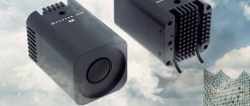
DJI has unveiled the Zenmuse L2 aerial LiDAR system.
The solution integrates frame LiDAR and a 4/3 CMOS RGB mapping camera, providing DJI flight platforms with more precise and reliable geospatial data acquisition. When used with DJI Terra, it delivers a turnkey solution for 3D data collection and accurate post processing.
Zenmuse L2 can allow for a precise scan of complex subjects within an extended range and faster point cloud acquisition. Users can preview, play back and process point cloud models on site during operations, with Task Quality Reports generated by DJI Terra. It can collect both geospatial and RGB data from a 1.5-mile area in a single flight, achieving 1.6" vertical accuracy and 2" horizontal accuracy.
The DJI Zenmuse L2 lists for $13,560.
Follow DJI on Facebook, Twitter and Instagram.
Follow American Cinematographer on Facebook, Twitter and Instagram.


